


What’s it all about?
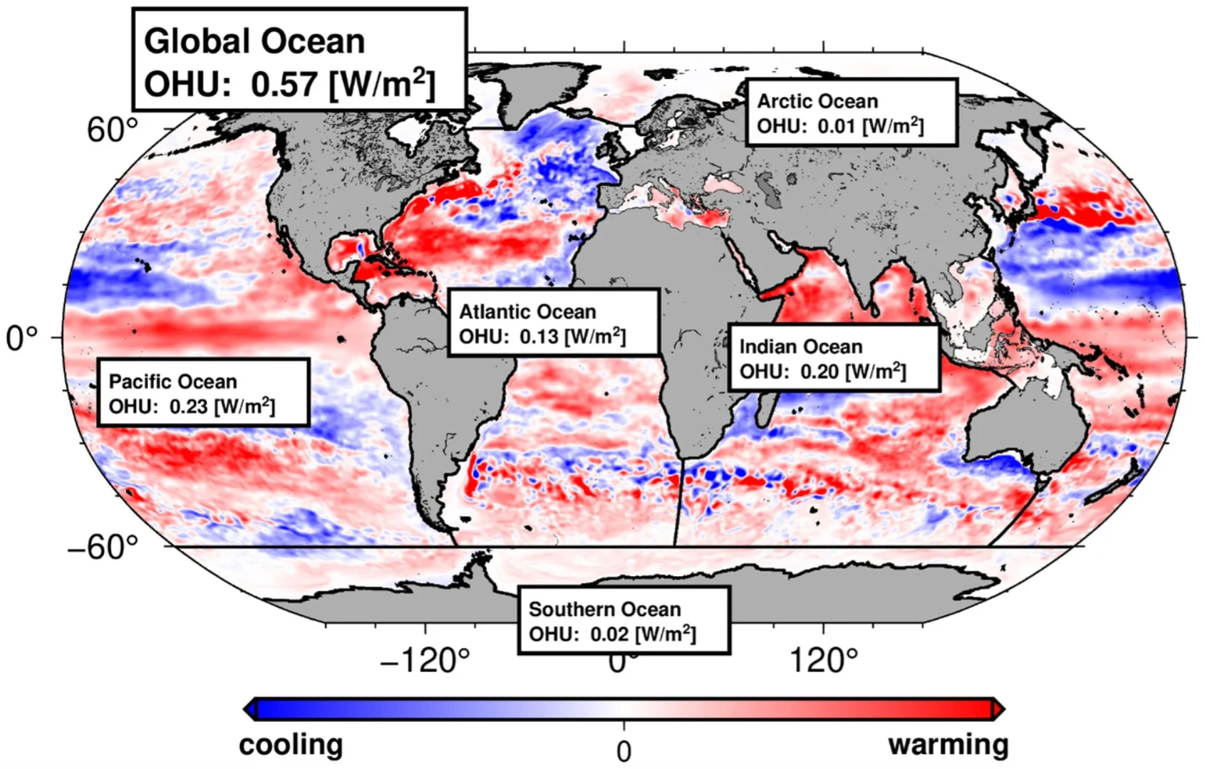
The Earth is currently absorbing more heat than it radiates into space. About 90 percent of this additional heat is absorbed by the oceans. Among other things, this influences sea level, marine heatwaves, and weather phenomena such as El Niño. Until now, freely drifting submersible buoys have been used to measure how heat is distributed in the ocean, but their coverage and sampling of the ocean is incomplete. Our approach combines measurements from buoys with sea level data from satellites. From this, we can reconstruct monthly maps and the warming of the entire ocean. This allows us to better determine how much heat the ocean absorbs and redistributes. Our method directly determines the total warming, averaged across all ocean depths. From this, global warming values can then be calculated.
What is the most important finding?
When considered across all oceans, our results are largely consistent with climate models. However, for individual ocean basins, there are significant differences from the model simulations, in the double-digit percentage range. The Indian Ocean, in particular, absorbed an unusually large amount of heat from 2005 to 2015. Over the past 20 years, the Pacific, Atlantic, and Indian Oceans have each absorbed about one-third of the additional heat. This suggests heat transfer between the oceans.
How did you conduct the study?
We combine measurements from buoys with data from various satellites. Radar altimeter satellites measure sea level very accurately. Since water expands when heated, rising temperatures cause sea levels to rise by a few millimeters each year—similar to what happens in the tube of a liquid thermometer. However, sea levels are also rising due to melting glaciers and ice sheets. Therefore, these influences must be factored out. To do this, we use measurements from the GRACE satellites. This allows us to determine the warming of the entire ocean and create maps of its spatial distribution. The buoy data also enable us to measure the warming of the upper ocean layers. This allows us to estimate how the additional heat is distributed at different depths in the ocean.
What was the biggest challenge?
What’s new is that, for the first time, we’re calculating the ocean’s coefficient of thermal expansion for different regions. This value was usually assumed to be the same everywhere in related studies, which can lead to significant errors. Our study combines large and very diverse datasets that must be analyzed consistently. Modern computational methods help us to account for differences in data distribution and minimize misinterpretations as much as possible.
What do you recommend based on the results?
Heat uptake and redistribution in the oceans can change dramatically within just a few years. The causes and consequences are not yet fully understood. That is why reliable measurements from satellites and ocean-based monitoring systems are particularly important. It is crucial to establish long-term funding for this through global cooperation, while at the same time reducing dependence on the United States. Climate policy should not focus solely on trends in average land surface temperatures. The ocean—and sea-level rise in particular—is actually a better “thermometer of the Earth system” because it is subject to far fewer fluctuations. The increasing warming of the oceans will have long-term consequences. This makes it all the more important to take measures that limit warming, mitigate its consequences, and enable effective adaptation to climate change.
What’s next?
We want to expand the analysis to earlier decades. To do this, we’ll use historical measurements, since there is less satellite data available prior to 1993. We also plan to include data from the upcoming GRACE-C and NGGM satellites in the future.
What is the source?
Bernd Uebbing, Kristin Vielberg, Roelof Rietbroek, Bene Aschenneller, Armin Köhl, and Jürgen Kusche: “Improving global and regional ocean heat content by consistently combining GRACE gravity, satellite altimetry, and Argo profile observations in a joint inversion framework,” Earth System Science Data, https://doi.org/10.5194/essd-18-6945-2026. The work was funded by the Deutsche Forschungsgemeinschaft as part of Research Group FOR5361.
Where can I find out more?
Dr.-Ing. Bernd Uebbing, Institute of Geodesy and Geoinformation at the University of Bonn, Tel. +49 (0)228 739360, Email: uebbing@geod.uni-bonn.de; Prof. Dr.-Ing. Jürgen Kusche, Institute of Geodesy and Geoinformation, member of the transdisciplinary research areas “Modeling,” “Matter,” and “Sustainable Futures” at the University of Bonn, Tel. +49 (0)228 732629, Email: kusche@uni-bonn.de